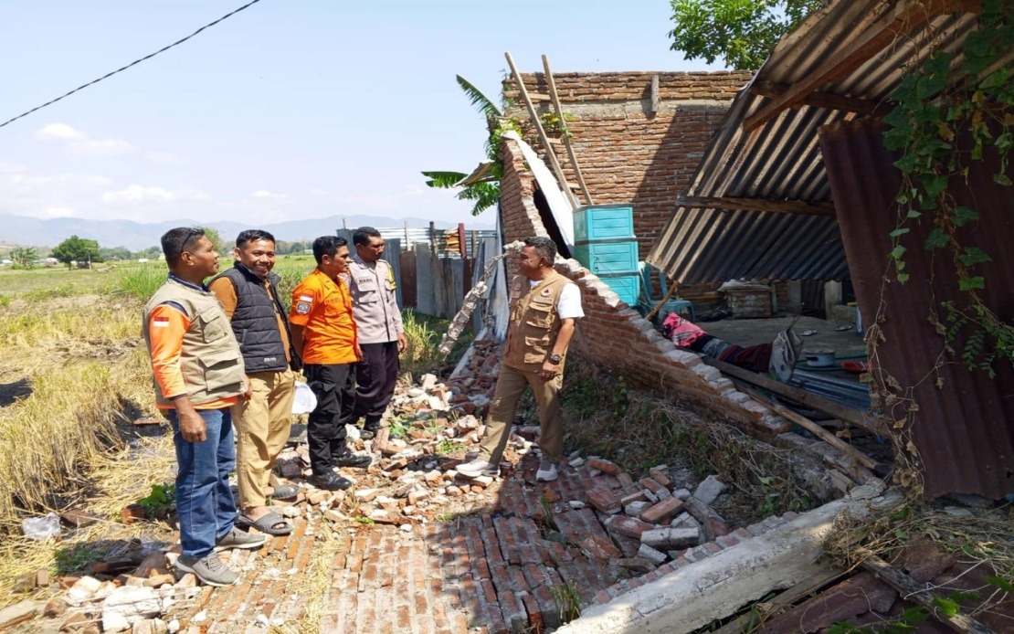
Indonesia's eastern Flores Island has been struck by a devastating magnitude 7.7 earthquake in the early hours of Saturday morning, triggering a major humanitarian crisis that has claimed at least 38 lives with rescue teams still searching for residents believed to be entombed beneath collapsed structures. The natural disaster, which originated in the sea approximately 30 kilometres from Mbay at a depth of 15 kilometres and struck at 4:58 am local time, has mobilised the entire apparatus of Indonesian disaster response, with authorities warning that casualty figures are expected to rise as assessment work continues throughout the affected zones in East Nusa Tenggara.
According to Suharyanto, chief of the National Disaster Management Agency (BNPB), the earthquake has created a complex rescue scenario with at least two individuals in critical condition and another 11 sustaining injuries ranging from moderate to minor. Beyond those physically harmed, approximately 2,000 residents have already evacuated the area independently, driven by fear of further seismic activity or concerned about building integrity. However, the critical challenge remains the location and extraction of an undetermined number of people whose whereabouts remain unknown and who may be trapped within damaged residential buildings and public facilities throughout the impacted region.
The immediate trigger for the quake initiated a tsunami alert that sent coastal residents into panic, prompting precautionary evacuations from shoreline communities. Authorities lifted the warning at 7:31 am after continuous monitoring of sea-level movements revealed no significant or threatening tidal anomalies. This represented a crucial piece of good news in an otherwise catastrophic scenario, as a major tsunami could have exponentially increased casualties and damaged the region's critical port infrastructure further.
The structural damage across Flores has been extensive and varied. Dozens of residential dwellings have been destroyed or severely compromised, rendering them uninhabitable for their occupants. Several community health centres that serve as vital medical facilities for rural populations have sustained damage, complicating medical response efforts precisely when they are most needed. The earthquake's violent movement has also triggered secondary geological hazards, with multiple landslides now blocking critical road networks that rescue teams desperately need to access affected villages and transport displaced persons to safety and shelter.
Transport infrastructure has not been spared from the earthquake's destructive force. The airport terminal building has incurred damage, though crucial details indicate the main runways have remained serviceable for emergency operations and relief flights. Two port facilities have also been affected by the seismic waves, potentially constraining maritime logistics necessary for delivering relief supplies to coastal communities. These transportation vulnerabilities compound the logistical nightmare facing relief coordinators attempting to move personnel, medical supplies, and humanitarian aid to remote areas of the island that may be temporarily isolated by damaged roads and compromised infrastructure.
Suharyanto has prioritised immediate search and rescue operations as the cornerstone of the government's response strategy. The National Search and Rescue Agency (Basarnas) has been activated alongside personnel from the Indonesian military and police forces to conduct systematic searches of damaged areas and extract survivors from structural debris. This coordinated approach reflects the scale of the operation required, as locating individuals buried beneath rubble across a large geographic area demands significant manpower and specialist equipment.
Parallel to rescue efforts, the Indonesian government has initiated infrastructure restoration as the second major priority. The Ministry of Public Works has deployed teams and heavy machinery specifically targeted at clearing roads blocked by landslides, understanding that restored access corridors are essential for both evacuation operations and the delivery of humanitarian assistance. These engineering teams face the dual challenge of working quickly under time pressure whilst ensuring their clearance operations do not trigger additional landslides that would further impede mobility.
The air dimension of the relief response has been mobilised rapidly, with the BNPB deploying two helicopter aircraft and one fixed-wing plane to conduct aerial evacuations of isolated or injured persons and to transport critical supplies to communities cut off by road damage. The helicopter capacity is particularly valuable for reaching mountainous or remote terrain where ground-based logistics cannot operate efficiently. These aircraft represent a lifeline for both emergency patient transfers requiring advanced medical care and for reaching population clusters that would otherwise remain isolated for extended periods.
Humanitarian agencies have begun distributing essential relief items to displaced populations and evacuation centres. The current distribution includes food supplies, potable drinking water, additional clean water for sanitation purposes, temporary shelter in the form of tents, electrical generators necessary for maintaining basic services, and other critical items addressing immediate survival needs. These supplies are directed toward the approximately 2,000 residents who have already self-evacuated and any additional persons who require assistance in the coming days as the full scale of displacement becomes clear.
For Malaysia and the broader Southeast Asian region, the Flores earthquake serves as a stark reminder of the region's intense seismic vulnerability. Indonesia's position along the Pacific Ring of Fire subjects it to recurrent major earthquakes, and this event underscores the importance of robust disaster preparedness infrastructure, building code enforcement, and regional cooperation in emergency response. The speed and scale of Indonesia's mobilised response demonstrates institutional capacity, yet also highlights the constant threat that geological hazards pose to regional stability and development. Malaysian authorities and ASEAN partners will likely be monitoring this situation closely, considering implications for regional disaster management protocols and the potential humanitarian assistance that might be coordinated through existing regional frameworks.

