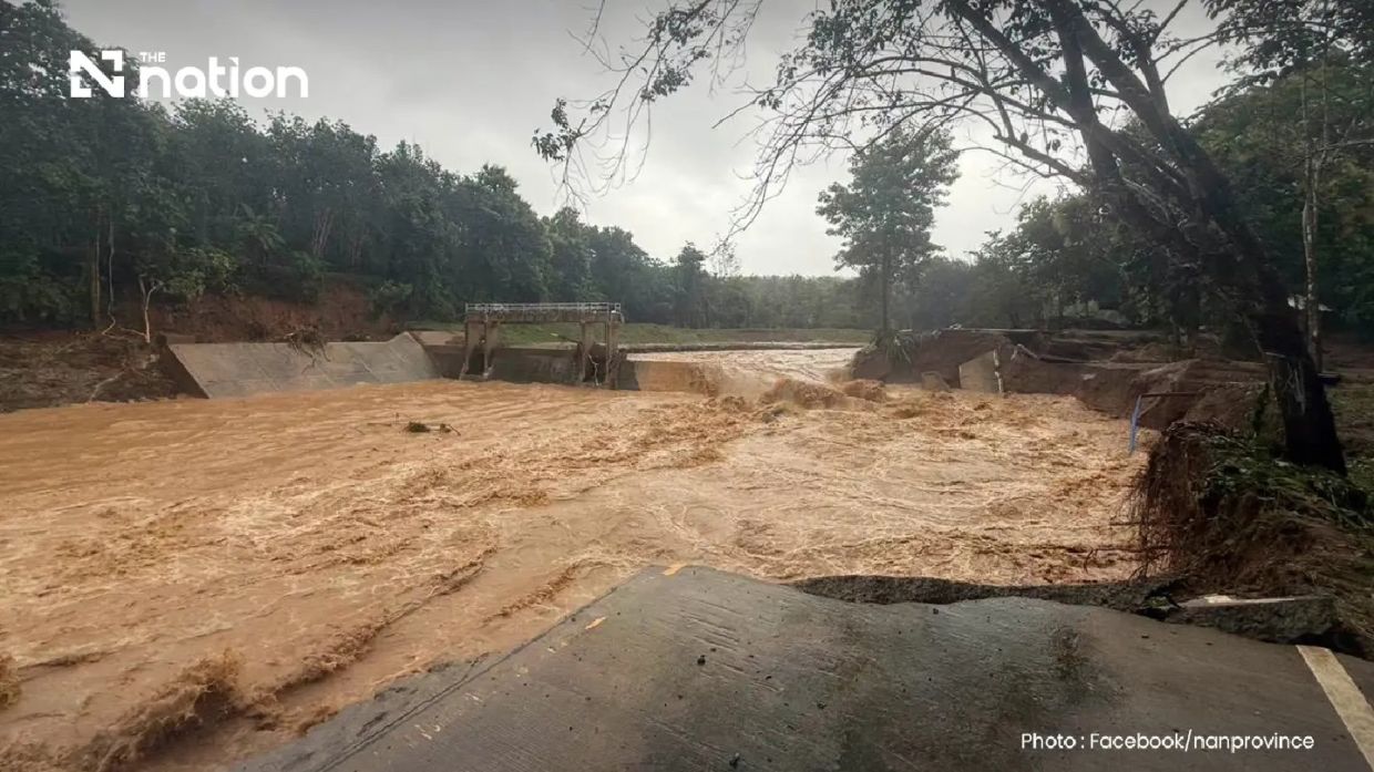
The mountainous districts of northern Thailand's Nan province experienced severe flooding on Wednesday morning as over 110mm of rain descended within a single night, triggering a cascade of water-related disasters that left communities scrambling to reach safety and authorities mobilizing emergency response teams across multiple affected zones.
The deluge centred on Pua district's high-elevation Phu Kha subdistrict, where the Doi Phu Kha National Park office recorded the extraordinary rainfall that transformed hillside streams into torrents. By dawn, residents in Pua and surrounding areas were already witnessing water inundating residential compounds and agricultural plots, with the speed of onset leaving little opportunity for families to secure their possessions, household electronics, and animal companions before floodwaters breached their homes. The timing and intensity of the overnight precipitation exemplifies the hazards facing communities in Thailand's northern foothills, where monsoon systems and topographical characteristics combine to create conditions prone to sudden, destructive flooding.
Infrastructure damage proved severe and widespread. A crucial bridge serving Ban Na Lae, which provides access toward Doi Phu Kha National Park and onwards to Bo Kluea district, was completely washed away, rendering the route entirely impassable. Authorities from Nan Highway District 2, operating under the Department of Highways, identified three separate points on major thoroughfares where water damage had made vehicle passage impossible, forcing travellers to seek alternative routes. The Fai Chao weir area also sustained bridge destruction, compounding the network of transportation disruptions that effectively isolated sections of the affected region.
Beyond water damage, geological hazards complicated the emergency response. The Ouan subdistrict area experienced multiple landslides that blocked access roads, hampering rescue and relief operations as officials attempted to navigate toward communities in need of urgent assistance. These secondary disasters, triggered by soil saturation and slope destabilization from the heavy precipitation, extended the scope of the crisis beyond the flooding itself and created additional obstacles for emergency services.
The Nan Provincial Disaster Prevention and Mitigation Office documented the unfolding situation, though the scale of damage continued to expand as waters receded and the full extent of destruction became apparent. The provincial authorities indicated they would issue further updates as the disaster evolved, acknowledging that the initial assessment captured only the immediate aftermath of the weather event.
Recognizing the acute threat to residents, the Department of Disaster Prevention and Mitigation coordinated with major Thai mobile network providers AIS, True, and NT to disseminate urgent warnings through the Cell Broadcast system. The emergency message delivered to residents' phones emphasized immediate evacuation priorities, instructing households to relocate belongings to elevated areas and to move vulnerable populations including elderly residents and bedridden patients to places of safety. The alert specifically directed those requiring evacuation or assistance to contact their subdistrict administrators, village heads, or local government organizations—recognizing that community leaders would likely serve as the primary coordination points for emergency response in areas where infrastructure had been compromised.
The broader meteorological context helps explain the disaster's intensity. The Northern Meteorological Centre, monitoring radar data from Lamphun, had detected bands of precipitation spanning nine provinces across upper northern Thailand, with weather patterns indicating continued precipitation moving toward the southwest. This regional perspective suggests that Pua's extreme rainfall, while locally concentrated, was part of a larger weather system affecting a substantial area, potentially placing other communities at subsequent risk as atmospheric conditions shifted.
The disaster highlights systemic vulnerabilities affecting Thailand's northern provinces each monsoon season. Communities built in river valleys and on hillsides face inherent exposure to flash flooding and landslide risks that no amount of advance warning entirely eliminates. While communication technology—the Cell Broadcast emergency alert system—now provides rapid information dissemination, the fundamental challenge remains: populations living in geographically hazard-prone areas require not only better warning systems but longer-term mitigation strategies including improved drainage infrastructure, early warning hydrology networks, and land-use planning that accounts for flood and landslide risks.
For Malaysian observers, the flooding in Nan province offers sobering parallels. Northern Malaysian states including Kelantan, Terengganu, and Perak experience similar monsoon-driven flash flooding, particularly during the Northeast Monsoon season. The rapid onset of disaster in Pua—the overnight transformation from manageable rain to life-threatening floods—mirrors situations that occur with alarming regularity in Malaysian river basins. The experience of Thai authorities coordinating responses across fragmented transport networks, establishing emergency communications with mobile carriers, and directing vulnerable populations to safety reflects challenges that Malaysia's own disaster management agencies confront repeatedly.
The incident also underscores how climate variability increasingly produces localized extreme weather events that standard infrastructure design may not accommodate. The 110mm rainfall that fell overnight in Pua represents roughly three months' worth of precipitation arriving within hours—a scenario that challenges drainage systems, road foundations, and hillside stability built according to historical precipitation patterns. As climate science indicates increasing frequency of such intense precipitation events across Southeast Asia, Thailand and Malaysia alike must accelerate investments in climate-resilient infrastructure and early warning systems.
Road authorities have advised travellers to avoid the Doi Phu Kha route entirely until damaged sections are repaired and assessed for safety. The disruption to transport networks, though temporary, illustrates how natural disasters create secondary economic impacts through supply chain interruptions and isolation of commercial centers from markets. For remote communities dependent on external trade and services, such infrastructure damage translates directly into economic hardship extending well beyond the immediate recovery period.

