A devastating magnitude 7.7 earthquake jolted Indonesia's Flores Island in East Nusa Tenggara province early Saturday morning, leaving at least 20 people dead and prompting one of the largest emergency evacuations in the region this year. The tremor, which struck at 4:58 am local time with its epicentre located roughly 30 kilometres offshore from the town of Mbay at a depth of 15 kilometres, triggered immediate alarm among residents still in their homes. According to the National Disaster Management Agency (BNPB), approximately 2,000 people were successfully evacuated by authorities, while many others independently sought shelter as the strong shaking and subsequent tsunami warning sent communities scrambling for safety.
The initial earthquake was followed by a series of powerful aftershocks, with authorities recording at least 111 tremors in the hours following the main event. The Meteorology, Climatology and Geophysics Agency (BMKG) issued a tsunami warning that remained in effect for nearly three hours before being lifted at 7:31 am after careful monitoring showed sea levels had stabilised without significant further rises. This precautionary measure, while necessary given the earthquake's magnitude and offshore location, added to the already tense situation facing island residents who were forced to evacuate to higher ground.
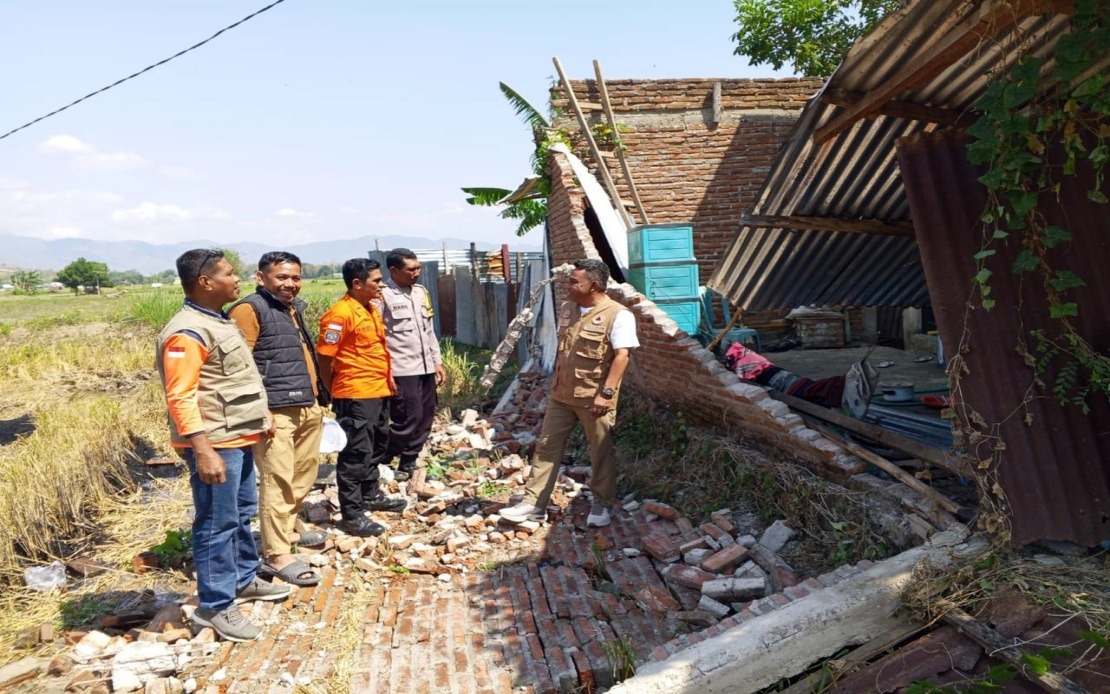
Berton Suar Pelita Panjaitan, the acting chief of the BNPB's Disaster Data, Information and Communication Centre, outlined the preliminary assessment of physical damage across the affected areas. A total of 54 houses sustained severe structural damage, nine experienced moderate damage, and 11 suffered minor damage, though authorities emphasised that these figures were preliminary and still being verified. Beyond residential structures, the disaster also impacted critical infrastructure, including five health facilities, one educational institution, three religious buildings, one warehouse operated by Bulog (Indonesia's state food logistics agency), and six government offices scattered across the region.
The Manggarai district, located on Flores Island, emerged as particularly hard-hit by the disaster. Preliminary reports indicated 29 houses were severely damaged there, alongside nine with moderate damage and another nine with minor structural issues. The neighbouring East Manggarai district also reported significant destruction, with 23 houses sustaining severe damage. These two adjacent districts appeared to bear the brunt of the earthquake's destructive force, suggesting the epicentre's proximity and the local soil composition may have amplified ground motion in these specific areas.
The death toll and injury count, while still being finalised, underscored the earthquake's lethal power. The Maumere Search and Rescue Office confirmed that six additional people were injured in the initial earthquake and subsequent aftershocks, while rescue teams were actively searching for two individuals reported trapped in collapsed or damaged structures. Recovery and rescue efforts were complicated by the scale of the disaster and the challenge of assessing conditions across mountainous terrain with limited road access in some communities.
Beyond the immediate physical damage, the earthquake severely disrupted modern communication infrastructure vital for coordinating emergency response and keeping residents informed. According to the Ministry of Communication and Digital Affairs, as many as 200 base transceiver station (BTS) sites across 10 different districts and cities throughout East Nusa Tenggara province experienced service disruptions by 7:00 am Saturday. These affected sites represented approximately 16.35 percent of the total BTS infrastructure in the impacted regions, a significant blow to telecommunications capacity at a moment when reliable communication was essential for emergency coordination and public safety information dissemination.
The Ministry's Digital Infrastructure director-general, Wayan Toni Supriyanto, confirmed that restoration efforts were underway in close coordination with private mobile operators serving the region. The telecommunications disruption meant that many residents in isolated or rural areas of Flores faced particular challenges in seeking help or receiving emergency instructions from authorities, potentially hampering rescue and relief coordination efforts. Restoring these communication links became a priority alongside search and rescue operations and medical response.
The scale of the evacuation and the mobilisation of resources reflected the serious threat posed by the earthquake and its aftermath. Regional disaster management agencies, Indonesian military personnel, national police forces, and local government officials worked in parallel to assess damage, verify casualty figures, monitor ongoing seismic activity, and address immediate humanitarian needs of affected communities. This multi-agency approach is standard protocol for major disasters in Indonesia but underscores the complexity of responding to a major earthquake that impacts urban centres, rural villages, and remote coastal areas simultaneously.
For Malaysia and the broader Southeast Asian region, the Flores earthquake serves as a sobering reminder of the seismic vulnerability that characterises much of the western Pacific. Indonesia sits along the Pacific Ring of Fire and experiences frequent seismic activity, with major earthquakes striking several times per year. While Malaysia's own seismic risk is considerably lower than Indonesia's, the Flores disaster illustrates the challenges facing developing nations in Southeast Asia when managing large-scale natural disasters—from evacuation logistics to telecommunications restoration to long-term reconstruction planning.
The extent of damage assessment continued throughout Saturday as teams fanned out across affected districts to compile comprehensive data. Officials acknowledged that preliminary figures would likely change as ground surveys progressed and information from remote communities arrived. The BNPB stressed that impact verification was ongoing, with various agencies continuing to document structural damage, assess environmental impacts, and identify displaced residents requiring temporary shelter and basic humanitarian assistance in the days ahead.
Future recovery will pose substantial challenges for East Nusa Tenggara, a region already facing development constraints and infrastructure gaps. The destruction of health facilities and educational institutions compounds difficulties for a province with limited economic resources. International assistance requests were anticipated, and the Indonesian government would likely seek support through disaster relief mechanisms to help restore critical infrastructure and support longer-term reconstruction efforts in Manggarai and East Manggarai districts.

