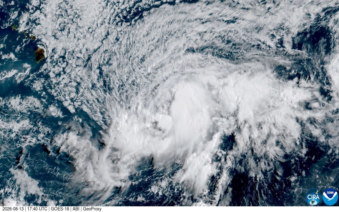
Tropical Storm Lala is on course to intensify into a full hurricane before making its approach toward Hawaii's Big Island this weekend, according to meteorological forecasts released Thursday. Officials have issued formal warnings as the system strengthens over the central Pacific, with the potential for destructive impacts including torrential rainfall, severe flooding, and strong winds capable of sparking wildfires across the volcanic terrain of the state's largest island.
The National Hurricane Centre projects that Lala will reach hurricane classification well before its anticipated arrival on Saturday, marking a significant escalation from its current tropical storm status. This intensification timeline reflects the warm ocean conditions and favourable atmospheric patterns that have allowed the system to gain strength as it moves westward across the Pacific basin. Forecasters emphasize that the transition from tropical storm to hurricane represents not merely a categorical distinction but a substantial increase in destructive potential.
What renders this event particularly noteworthy is its rarity within Hawaii's recorded meteorological history. Should Lala make landfall on the Big Island, it would represent the first hurricane strike on the island in over 150 years, dating back to 1871. That previous hurricane, documented through meticulous research of historical newspaper accounts by University of Hawaii atmospheric scientists, struck the northeast corner of the island as a Category 3 system. The extended interval between major hurricane landfalls means current infrastructure, building codes, and emergency response systems have evolved significantly without recent direct experience of such phenomena.
Vanessa Almanza, a meteorologist with the National Weather Service in Honolulu, underscores the significance of this occurrence from a modern perspective. She notes that while the 1871 hurricane represents Hawaii's most recent direct hurricane strike, satellite-era meteorology provides unprecedented observational capability today. The latest computational forecasts place Lala's track very close to the Big Island's southern tip, indicating that the island faces genuine exposure to the system's most dangerous core should the projected path hold.
The spatial distribution of warnings reflects the varying threat levels across the Hawaiian archipelago. A full hurricane warning has been issued specifically for the Big Island, indicating that hurricane-force winds and associated hazards are expected within that geographical area. In contrast, a tropical storm warning extends to Maui County, the administrative designation encompassing the islands of Maui, Molokai, Lanai, and Kahoolawe. This tiered warning structure allows residents to calibrate their preparation and response efforts according to their specific exposure levels.
The dual hazards posed by such a system merit careful consideration. Heavy precipitation from a tropical cyclone moving across mountainous terrain can trigger flash flooding in valleys and stream channels, particularly in areas with poor drainage or previous saturation. Simultaneously, the strong winds accompanying a hurricane can topple trees, strip vegetation, and create abundant dry fuel material that becomes ignitable when combined with the friction-induced heating that sometimes follows weather systems' passage. This combination of water and fire hazards creates a complex emergency management scenario.
For Malaysian and Southeast Asian observers, this Hawaiian situation offers relevant lessons regarding extreme weather preparedness in island and tropical contexts. While Malaysia experiences typhoons and tropical depressions regularly, the question of how infrastructure withstands direct hurricane strikes after extended periods without such events remains pertinent to regional disaster risk reduction planning. The evolution of building standards, emergency communication systems, and evacuation protocols over 150 years reflects accumulated knowledge that increasingly informs global best practices.
The Big Island's exposure also highlights vulnerabilities particular to volcanic islands with dispersed populations and limited evacuation routes. The island's terrain, shaped by geological processes fundamentally different from those creating flatter landmasses, creates unique challenges for emergency response and infrastructure resilience. These geographical realities make advance preparation and timely warning systems essential elements of public safety strategy.
Community response mechanisms have been activated ahead of the anticipated weekend impact. Residents face decisions regarding sheltering in place, evacuation, or other protective measures based on their specific locations and circumstances. The National Weather Service and state emergency management officials provide regular updates as the system's trajectory becomes more precisely defined, allowing continual refinement of preparedness actions.
The meteorological significance of Lala extends beyond Hawaii itself, representing broader patterns in tropical cyclone behaviour and climate system dynamics. Scientists monitor such systems to enhance understanding of the physical processes driving hurricane intensification and track evolution, knowledge that contributes to improving forecast accuracy for future events across the Pacific and globally. Each major weather system offers data points that refine the collective scientific understanding of atmospheric behaviour.

