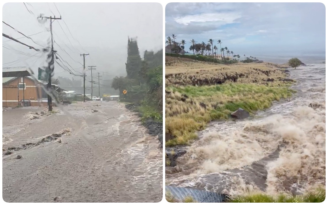
Hurricane Lala descended upon Hawaii on Saturday, August 15, delivering a powerful blow to the island chain with torrential downpours, destructive winds and extensive infrastructure damage. The storm tracked just south of Hawaii Island, bringing dangerous conditions that persisted throughout the day and into the evening. The scale of the disruption became immediately apparent, with electricity providers reporting that more than 88,000 customers across the Hawaiian islands had lost power by the evening hours, marking one of the more significant weather-related outages in recent memory.
Governor Josh Green characterised the situation as rapidly deteriorating across multiple islands. Hawaii Island bore the brunt of the initial onslaught, with wind conditions at their most severe there during peak hours. The rainfall proved particularly intense in certain locations, with official measurements showing some areas had already accumulated more than 13 inches by mid-afternoon. Beyond Hawaii Island, conditions were escalating across the neighbouring Maui County, as well as the more densely populated islands of Oahu and Kauai, indicating the storm's broad geographic footprint across the state.
The Hawaii Emergency Management Agency documented cascading infrastructure failures as the storm's power became evident. Flooding emerged as an immediate threat in low-lying areas, while the powerful winds snapped trees across multiple islands and downed power lines in critical locations. The combination of these factors created a compound disaster scenario, where residents faced not only the immediate danger of the storm itself but also the secondary hazards of blocked roads, downed utilities and hazardous debris scattered across communities.
Hawaiian Electric, the state's primary utility provider, released detailed breakdowns of the outages affecting different regions. Hawaii Island accounted for the vast majority of disconnections, with 63,270 customers losing electricity—roughly 72 percent of the total. Maui County experienced approximately 15,260 outages across its island communities, while Oahu, the state's most populous island home to Honolulu, saw about 9,500 customers without power. These figures, compiled as of 7 p.m. Hawaii Standard Time, represented a snapshot of a rapidly evolving situation that continued to worsen as the storm moved across the islands.
The Department of Transportation documented the storm's physical impact through visual evidence, releasing footage that captured the scale of flooding in real time. Swollen streams overflowed their banks, while roads designed for normal rainfall became impassable waterways. The agency subsequently identified and closed multiple routes across all three affected islands, creating significant disruptions to commerce and emergency response capabilities. Officials issued urgent directives for residents to either remain sheltered in their homes or move to designated emergency shelters, recognising that venturing outdoors posed unacceptable risks.
Local police departments reported widespread disruption across Hawaii Island as the storm progressed. In the Mountain View area, flooding forced the closure of Kahikopele Street, cutting off access to that neighbourhood. Pauahi Street experienced significant water damage that affected traffic flow and accessibility. The Mamalahoa Highway, a critical thoroughfare, became treacherous due to fallen trees and large debris scattered across the roadway, creating hazards that persisted even as wind speeds eventually began to subside. Downed power lines added another layer of danger, leading authorities to close Plumeria Street and establish perimeters around other affected areas.
Wind measurements provided by Hawaiian Electric underscored the storm's intensity and the structural damage it inflicted. Gusts approaching 90 miles per hour were recorded on Hawaii Island, velocities sufficient to snap mature trees and compromise utility infrastructure. The force of these winds proved particularly devastating along the Hamakua coast, where a concentrated 42-mile stretch of transmission lines experienced catastrophic damage. Fallen trees brought down multiple utility poles and structures, severing connections that supplied electricity to thousands of customers. The concentrated nature of this damage suggested that restoration efforts would require extensive coordination and significant time investment.
Utility officials delivered sobering assessments regarding the timeline for power restoration. Customers already experiencing outages on Hawaii Island and Maui were advised that they should expect to remain without electricity throughout the night at minimum. The dangerous conditions persisting across both islands—continuing high winds, scattered debris, and hazardous flooding—made it impossible for repair crews to safely access damaged infrastructure and begin restoration work. This extended outage window meant that residents would need to prepare for an extended period without air conditioning, refrigeration, lighting and other essential electrical services.
For Malaysian and Southeast Asian readers, Hurricane Lala serves as a sobering reminder of the vulnerability of developed island economies to tropical weather systems. Hawaii's experience demonstrates how even relatively advanced infrastructure networks can be overwhelmed by extreme weather, with cascading failures affecting power, transportation and emergency services simultaneously. The storm's impact raises questions about climate resilience and disaster preparedness that resonate across the Pacific region, where similar weather patterns increasingly threaten populated island communities. The coordination challenges evident in Hawaii's response—managing simultaneous crises across multiple islands, prioritising emergency services, and communicating with a dispersed population—reflect challenges that Southeast Asian nations with archipelagic geography must also consider as climate patterns intensify.

