Japan faces a potentially devastating weather event as two separate typhoons bear down on the island nation, with the Japan Meteorological Agency issuing heightened alerts on Friday for conditions expected to intensify through the weekend. The dual system presents an unusually complex meteorological challenge, with Typhoon Higos approaching from the Pacific and Typhoon Mekkhala already in closer proximity off Okinawa's coast. This convergence has prompted authorities to prepare for sustained heavy rainfall and wind damage across multiple regions simultaneously, a scenario that stretches emergency response capabilities.
Typhoon Mekkhala began its approach to southwestern Japan on Friday, bringing dangerous conditions to the Amami region in Kagoshima Prefecture before potentially shifting toward the densely populated Kanto region. Simultaneously, Typhoon Higos tracked toward landfall along Japan's southern coast, with projections suggesting the system would make contact with the mainland during the weekend period. While meteorologists anticipate both typhoons will lose their tropical characteristics and transform into extratropical cyclones upon reaching land, the transition often brings erratic weather patterns that can prove equally hazardous. The timing of these two systems—one consolidating offshore while the other approaches—creates a window of heightened vulnerability that has prompted an unprecedented mobilization of civil protection resources.
Evacuation orders underscore the severity of anticipated conditions, with over 2 million residents across 13 prefectures in the Kinki and Kyushu regions directed to leave their homes by Friday morning. The scale of displacement reflects official concern that rainfall volumes could trigger widespread geomorphological hazards across mountainous and sloped terrain. In Seika, Kyoto Prefecture, authorities implemented the maximum level 5 emergency safety alert after a landslide materialized during Friday morning hours, demonstrating that ground instability remained an immediate threat even before the primary systems arrived. These evacuation orders represent weeks of logistical coordination with shelters, transport provision, and supply chains—indicating that meteorological forecasts had provided sufficient lead time for precautionary population movement.
Rainfall accumulations recorded between Tuesday and Friday morning illuminate the atmospheric rivers already channeling moisture across Japan's western regions. Goto in Nagasaki Prefecture registered 600 millimetres of precipitation, while Aso in Kumamoto Prefecture and Ureshino in Saga Prefecture both exceeded 500 millimetres during the same period. These measurements, though recorded before the major typhoon systems made full contact, already approached or exceeded monthly precipitation totals for many locations. The continued moisture influx from Typhoon Higos and Typhoon Mekkhala would superimpose additional rainfall on landscapes already saturated from the preceding multi-day deluge, exponentially increasing the probability of slope failures and flash flood generation.
Weather agency forecasts predicted intensifying precipitation across central Japan through Saturday, with particular concern directed toward the Tokai and Kanto regions—Japan's economic and demographic heartland. The Tokai region faced expectations of up to 300 millimetres of rain by noon Saturday, while the Kanto-Koshin zone would potentially receive 150 millimetres during the same timeframe. These volumes arriving within a compressed 24-hour window would overwhelm conventional drainage infrastructure in urbanized areas and create severe hazards across river valleys and coastal plains. The Kanto region in particular, encompassing Tokyo and surrounding prefectures, warrants elevated concern given the region's enormous population concentration and complex interdependencies in transportation and utilities networks.
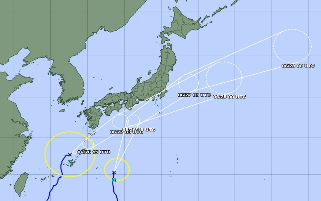
Typhoon Mekkhala's position as of Friday mid-morning—located off Okinawa's Kume Island and progressing northeastward at 15 kilometres per hour—indicated relatively slow progression that would prolong wind and rainfall impacts across regions in its path. The deliberate forward movement contrasts with faster-moving systems that deliver concentrated impact over brief periods; the extended exposure window amplifies cumulative precipitation potential and allows successive wave energy from storm surge to compound coastal erosion. Okinawa Prefecture, positioned directly in Mekkhala's trajectory, would experience the system's core intensity, though the island's exposure to tropical cyclones annually provides institutional experience with protective measures.
The Japan Meteorological Agency's warnings extended to all Japanese residents, emphasizing vigilance against secondary hazards that frequently prove deadlier than primary wind damage. Landslides in mountainous regions, flooding along river corridors, and storm surge along exposed coasts represent the principal mechanisms through which typhoons generate casualties and economic losses. The agency specifically flagged the possibility of severe convective activity—localized thunderstorms embedded within the broader typhoon circulation—that can produce extreme rainfall intensities over limited areas, overwhelming drainage capacity even in engineered flood management systems. Public communications emphasized the unpredictability of tropical cyclone behaviour, noting that track forecasts possess inherent uncertainty ranges that expand with projection timeframe.
From a Southeast Asian perspective, Japan's meteorological response mechanisms and civil protection apparatus offer instructive examples of typhoon preparedness, though the region's varying developmental contexts and resources require careful adaptation rather than direct replication. Malaysia and other ASEAN nations sharing Pacific typhoon exposure belts can observe Japan's use of tiered alert systems, precise quantitative rainfall forecasting, and prepositioned evacuation infrastructure as potential benchmarks for refinement. The coordination between Japan Meteorological Agency advisories and Fire and Disaster Management Agency enforcement mechanisms demonstrates institutional integration that proves essential during extreme weather events when fragmented authority structures can create response delays.
The dual typhoon system also carries implications for regional maritime and aviation authorities throughout Southeast Asia, as these systems can generate indirect impacts through disrupted transportation networks and delayed cargo movements. Businesses with supply chain dependencies on Japanese ports or manufacturing facilities must anticipate weekend disruptions. Insurance markets in the region typically incorporate Japanese weather patterns into pricing models for regional coverage, as catastrophic losses in Japan often trigger broader market adjustments affecting neighboring economies. The forecasted transformation of both typhoons into extratropical cyclones upon landfall suggests that post-weekend conditions could produce residual moisture transport across broader areas, potentially influencing weather patterns across the East China Sea and western Pacific routes utilized by regional maritime traffic.
As the weekend approached, Japan positioned itself for a critical test of disaster response systems under compound stress conditions. The simultaneity of two major typhoons, combined with antecedent rainfall saturation and elevated population exposure in the Kanto region, created a scenario where emergency responders would face difficult resource allocation decisions. Public compliance with evacuation orders and protective actions remains contingent on continued accurate meteorological communication and perceived legitimacy of warnings—factors that Japan's long institutional experience with tropical cyclones has cultivated through decades of consistent, transparent forecasting and demonstrated institutional competence.