Chinese authorities have officially determined that a catastrophic avalanche originating from Nepal's Mount Langtang Lirung glacier caused the devastating mudslide that struck Gyirong Port in southwest China's Xizang Autonomous Region on August 26. The confirmation came from the regional government's information office on Sunday, following investigations by a specialized disaster response team. The finding underscores the cross-border nature of natural hazards in the Himalayan region and raises urgent questions about international cooperation in monitoring high-altitude mountain phenomena that threaten communities on both sides of political boundaries.
The sequence of events that unfolded demonstrates the terrifying speed and scale of alpine disasters. The glacier fractured at approximately 5,200 metres on the south slope of Mount Langtang Lirung, a major peak straddling the Nepal-China border. As the massive accumulation of ice and rock broke free from its moorings, it accelerated rapidly downslope, descending nearly 1,200 metres in the initial phase of the collapse. During this descent, the avalanche scooured exposed mountainside and picked up additional debris—rocks, soil, vegetation, and water—transforming from a relatively confined ice event into something far more destructive and unpredictable.
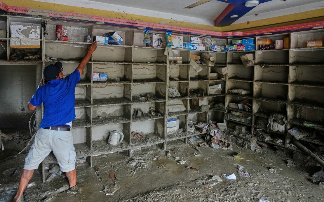
The debris flow continued its destructive journey across the landscape for approximately 22 kilometres before eventually reaching Gyirong Port, which sits at a considerably lower elevation of around 1,800 metres. By the time the mudslide arrived at its final destination, it had accumulated sufficient mass and momentum to obliterate an entire area spanning 0.7 square kilometres. Twenty-seven buildings and associated structures lay in ruins, erased from the landscape entirely. The sheer destructive power vividly illustrates how an event originating in the heights of the Himalayas can propagate across vast distances, transforming from a mountain phenomenon into a regional catastrophe.
The human toll remains staggering as recovery efforts continue. As of Saturday evening, 16 lives had been confirmed lost in the disaster, while 546 individuals remained missing and unaccounted for. For context in the Southeast Asian region, such casualty figures would rank among the deadliest natural disasters in recent memory. The scale of missing persons suggests that many individuals were simply overwhelmed and buried by the advancing mudslide, with recovery operations likely to stretch across weeks or longer. Families across the region face agonizing uncertainty regarding the fate of relatives and loved ones caught in the path of the flow.
The investigation into the disaster's origins was conducted by a specialized cryosphere emergency disaster response team from the Institute of Mountain Hazards and Environment, which operates under the Chinese Academy of Sciences. This team employed sophisticated modern methodologies including remote-sensing satellite monitoring data, field-transmitted sensor readings, and comprehensive on-site surveys to piece together the sequence of events. Their work represents the application of cutting-edge geophysical science to understand how high-altitude phenomena manifest and propagate across the landscape. The team's findings provide valuable documentation for the broader scientific community studying glacial hazards in the world's highest mountain ranges.
Mounting temperatures across the Himalayan region have placed glaciers under unprecedented stress in recent decades. Scientists worldwide have documented accelerating glacier retreat and destabilization in the higher altitudes, phenomena linked to regional and global climate patterns. The fracturing of the Mount Langtang Lirung glacier reflects this broader trend of increasing instability in mountain systems that have remained relatively stable for generations. For countries in South and Southeast Asia that depend on glacier-fed river systems for water supplies, agriculture, and hydroelectric power, such events carry implications extending far beyond immediate disaster response and into long-term resource management and adaptation planning.
The incident highlights a critical gap in disaster preparedness and early warning systems that operate across international boundaries. Gyirong Port, though located in Chinese territory, faces hazards originating from Nepalese mountains. This geographical reality demands coordination between neighbouring countries to establish monitoring networks, share real-time data, and develop joint response protocols. Currently, such cross-border cooperation in the Himalayan region remains underdeveloped, leaving communities vulnerable to hazards they cannot independently monitor or control. The disaster provides sobering evidence that international frameworks for managing shared natural hazards require urgent development and implementation.
For Malaysian observers and Southeast Asian nations more broadly, the Gyirong incident offers instructive lessons regarding disaster resilience in mountainous and geologically active regions. While Malaysia's topography differs substantially from the Himalayas, the principles of disaster preparedness—investment in monitoring technology, integration of real-time data into response systems, and maintenance of evacuation protocols—apply universally. Several Southeast Asian nations, particularly those with significant highland populations or border regions adjacent to seismically active zones, face comparable vulnerabilities to cross-border natural hazards. Learning from China's investigation methodologies and response procedures could enhance regional capacity to handle similar events.
The economic dimensions of the disaster extend beyond immediate infrastructure damage. Gyirong Port operates as a significant trade gateway between China and Nepal, facilitating bilateral commerce and serving as a crucial link in regional supply chains. The destruction of 27 buildings and related facilities will disrupt cross-border trade operations, with cascading effects on regional commerce and economic activity. Reconstruction will demand substantial financial investment, and the port's closure during recovery operations will necessitate diversion of trade routes and alternative arrangements for bilateral commerce. These economic consequences ripple through supply networks connecting South Asia with China and beyond.
The disaster also underscores vulnerabilities in infrastructure placement and planning in high-altitude regions. Gyirong Port, despite its strategic importance, appears to have been constructed within a hazard zone without comprehensive risk mitigation measures. Future reconstruction and new development projects in such locations will require more sophisticated hazard assessment, incorporation of protective infrastructure, and potentially relocation of critical facilities to safer ground. Chinese and Nepalese engineers will likely incorporate lessons from this event into updated building codes and land-use planning frameworks for the border region.
Climate adaptation considerations emerge as perhaps the most sobering implication of the Gyirong disaster. If glacier instability is indeed increasing due to warming temperatures, then communities throughout the Himalayas and across Asia must anticipate more frequent such events. This reality demands proactive measures including enhanced monitoring networks, upgraded early warning systems, and acceleration of adaptation strategies that help communities adjust to increasingly unstable mountain environments. For Nepal and China specifically, this may necessitate difficult decisions regarding settlement patterns, infrastructure investment, and allocation of limited adaptation resources toward the most vulnerable populations.
The international scientific community will scrutinize findings from the Chinese Academy of Sciences investigation, as the Gyirong event joins a growing catalogue of major glacial disasters reshaping understanding of Himalayan hazards. Researchers across Asia, Europe, and North America studying cryosphere dynamics will incorporate data from this incident into models predicting future avalanche and debris-flow risk. The cross-border nature of the disaster emphasizes that climate change and its mountain-related consequences transcend political boundaries, requiring coordinated regional responses that acknowledge shared vulnerability and mutual dependence on effective hazard management systems.
As recovery operations intensify and investigation into the disaster deepens, the fundamental lesson emerges starkly: high-altitude mountain systems across Asia face accelerating instability, and communities below those mountains require strengthened international cooperation, advanced monitoring, and coordinated disaster preparedness. The 16 confirmed deaths and 546 missing persons at Gyirong Port represent not merely a tragedy in one border location, but a warning signal about systemic vulnerabilities in how Asian nations collectively confront natural hazards that increasingly refuse to respect territorial boundaries or conventional notions of isolated, localized disaster.

