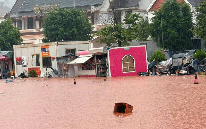
Luang Namtha province in northern Laos has been officially declared a disaster zone following a severe flooding event triggered by upstream rainfall and swollen river systems. The declaration, made by the Luang Namtha Provincial Administrative Committee on Saturday, August 29, follows flash floods and landslides that swept through the province's Luang Namtha and Nalae districts, affecting more than 30 villages across a vast geographical area. The inundation damaged residential structures, educational facilities, hospitals, sections of the Boten special economic zone near the Laos-China border crossing, and extensive agricultural land, though the border checkpoint itself remained operational throughout the crisis.
The flooding emerged as a cascade consequence of rapid rises in upstream river systems across the region. Days of heavy precipitation channelled vast volumes of water southward into Laos, with monitoring stations recording concerning water level readings. The Tha River hydrology station measured water depths reaching 6.58 metres on the day of the declaration, exceeding the standard 6-metre flood warning threshold and approaching the critical 7-metre benchmark that signals severe inundation risk. This rapid escalation underscores the vulnerability of northern Laos to monsoon-driven hydrological extremes, particularly in districts situated downstream from mountainous terrain where runoff concentrates quickly.
The meteorological and hydrological services operating under Laos's Ministry of Agriculture and Environment issued specific flood warnings for the Tha River covering August 29 and 30, alerting downstream communities to potential continued rises. Officials across five administrative districts received orders to prepare residents for possible evacuations, with particular emphasis on populations residing in riparian zones and topographically low-lying settlements. This proactive approach reflects lessons learned from previous seasonal flooding events that have periodically affected the region, though the coordination and communication systems remain stretched given the scale of territory and population dispersed across Laos's remote northern geography.
The immediate trigger for the disaster was the convergence of two atmospheric systems operating simultaneously over the region. A low-pressure weather system tracking across northern Laos and into adjacent southwestern China combined with the southwest monsoon circulation pattern to create conditions conducive to sustained heavy precipitation. Meteorologists forecast that this combination would produce scattered thunderstorms, moderate to heavy rainfall, and strong winds across a 14-province swathe of northern and central Laos through the weekend. The geographical extent of the warning—spanning from Phongsaly in the far north to Attapeu in the south—demonstrates the scale of the weather system affecting the country and the regional vulnerability to monsoon precipitation.
For Malaysia and Southeast Asian observers, this flooding event carries implications for understanding transboundary water management and climate resilience in the Mekong region. Luang Namtha's location as a critical juncture between Laos and China's Yunnan Province makes it strategically significant; the Boten special economic zone represents an important commercial corridor facilitating trade between the two countries. Disruptions to this infrastructure, even temporary ones, can cascade across regional supply chains and affect connectivity throughout Southeast Asia. The flooding also illustrates how climate variability, concentrated in intense monsoon seasons, creates recurring humanitarian challenges across Indochina's less-developed infrastructure regions.
The Boten border crossing specifically deserves attention, as it represents one of the major land gateways between mainland Southeast Asia and China. Though the checkpoint itself escaped major damage in this flooding episode, the surrounding special economic zone faced significant inundation, potentially disrupting warehouse facilities, logistics operations, and manufacturing establishments that depend on stable transportation corridors. For Malaysian enterprises engaged in regional trade, particularly those shipping goods through Laos toward China, such disruptions highlight the ongoing infrastructure vulnerabilities that characterize land-based commerce across the Mekong corridor.
Laos's provincial authorities initiated a comprehensive response strategy combining immediate alert systems with sustained monitoring. Local administrations were instructed to maintain close surveillance of river conditions, respond swiftly to emerging incidents, and furnish regular updates to provincial leadership. This bureaucratic apparatus, while establishing clear communication channels, ultimately depends upon ground-level capacity and resources that remain constrained in remote Lao communities. The effectiveness of evacuation protocols in practice often hinges on practical factors—availability of transportation, accessibility of high ground, and community familiarity with warning procedures—that extend beyond formal declarations.
The broader monsoon context frames this particular flooding event within Laos's annual cycle of seasonal hazards. The southwest monsoon, which dominates from May through September, regularly produces episodes of intense rainfall across the country, with northern provinces typically experiencing the most pronounced impacts due to their exposure to moisture-laden winds and their mountainous topography that channels runoff toward populated valleys. Climate scientists have documented that monsoon intensity has shown increasing variability in recent years, suggesting that the region may face more frequent extreme precipitation events as global climate patterns shift. This trajectory poses long-term challenges for development planning and disaster preparedness across Laos and its Mekong neighbors.
Residents throughout the 14 affected provinces received advisory guidance emphasizing the importance of continuous weather monitoring, heightened vigilance in high-risk areas, and readiness for potential evacuation orders. Such advisories, while essential, place considerable burden on communities already stretched by limited access to reliable communication networks and variable institutional support. The Lao government's public health and disaster management agencies have worked to strengthen early warning dissemination, yet significant gaps remain between warning issuance in national capitals and actual receipt of information in rural villages where many flood-vulnerable populations reside. Enhanced regional cooperation on meteorological forecasting and transboundary water data sharing—areas where the Mekong River Commission plays an important coordinating role—remains crucial for improving predictive capacity and response coordination.
The declaration of Luang Namtha as a disaster zone opens pathways for mobilizing additional resources, whether from national government reserves, international humanitarian organizations, or bilateral assistance partners. Laos maintains relationships with several major development partners, including Thailand, Vietnam, and China, all of which have experience in flood response operations. For the regional community, this episode serves as a reminder that climate-related disasters transcend borders and that investments in cross-boundary early warning systems, infrastructure resilience, and humanitarian coordination networks yield returns across the entire Mekong ecosystem.

