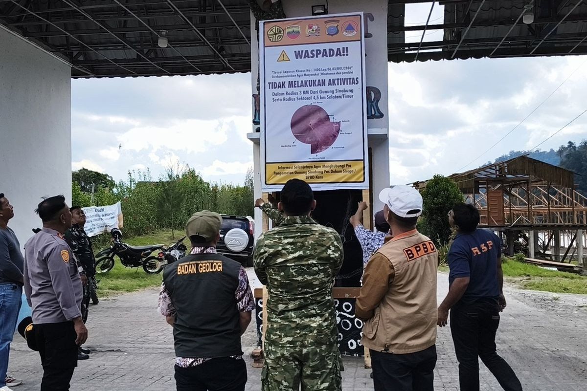
Mounting concern over volcanic instability in North Sumatra has prompted regional authorities to seal off popular tourism destinations around Mount Sinabung, signalling the start of a precautionary shutdown that may extend indefinitely. The Karo regency administration announced the temporary closure of Lau Kawar Lake and its associated camping facilities in Kuta Gugung village, Naman Teran district, beginning August 19 following a sharp increase in seismic tremors and gaseous discharge from the 2,460-metre volcano. The decision reflects official guidance from the Vulcanology and Geological Disaster Mitigation Center's monitoring command post stationed at the site, underscoring the seriousness with which Indonesian geological authorities are treating the current phase of volcanic unrest.
The alert escalation represents a significant shift in the volcano's status within Indonesia's four-tier warning system. Mount Sinabung has been elevated from Level I, denoting normal conditions, to Level II Waspada, which translates to an advisory status requiring heightened vigilance and restricted access. Armen Putra, head of the Mount Sinabung monitoring post, confirmed this upgrade and outlined the spatial restrictions now in effect: residents and tourists are advised to maintain at least three kilometres distance from the summit, with a more conservative four-point-five-kilometre exclusion zone designated for the south-easterly sector where pyroclastic flows typically extend during eruptions. The monitoring authority also issued a specific caution for populations residing along waterways that originate on the volcano's slopes, warning of potential mudflow hazards that accompany volcanic activity.
Recent instrumental data reveals a concerning intensification of seismic activity beneath the volcano. In the early hours of August 27 alone, the monitoring station detected five volcanic earthquakes, alongside additional tectonic activity originating from the broader regional geology. This contrasted markedly with the preceding day, which recorded just one volcanic quake and seven tectonic events. The significance of this acceleration lies in what seismologists understand about magma behaviour; increased earthquake frequency and magnitude typically precede eruptive episodes, suggesting that magmatic pressure is building beneath the surface. Officials have explicitly acknowledged this correlation, noting that the prevalence of tremors corresponds directly to heightened eruption potential.
The character of Mount Sinabung's current unrest extends beyond merely seismic signals. Volcanological observations document thick plumes of smoke and gas ascending between 100 and 800 metres above the summit, a visual indicator that deeply seated volcanic gases are escaping at pace. Such emissions, combined with the seismic drumbeat, paint a picture of a system in escalating flux. For the tourism sector in Karo regency, which has cultivated Lau Kawar Lake as a recreational draw, this represents an abrupt commercial interruption, though one deemed unavoidable given the proximity of the site to the active volcano and the potential consequences of inadequate precaution.
Mountain Sinabung's eruptive history over the past fourteen years demonstrates the volcano's capacity for both minor episodes and catastrophic explosions. After remaining dormant for approximately four centuries, the volcano returned to activity on August 29, 2010, beginning a new phase of intermittent eruptions that has continued sporadically through the present day. The 2013 eruption cycle proved particularly destructive, culminating in a major explosion in November that year which triggered the highest alert level and forced evacuations affecting dozens of villages and hamlets. That eruption produced deadly pyroclastic flows—superheated clouds of gas and ash moving at tremendous speed—which claimed numerous lives and underscored the genuine danger posed by the volcano to surrounding communities.
The most recent significant eruption occurred in July 2021, thirteen years into the current active phase, when Mount Sinabung expelled ash columns reaching 4,500 metres altitude and directed pyroclastic surges up to one kilometre eastward and southeastward. This event again demonstrated the volcano's destructive capacity and affected multiple districts through blanketing ash fall. Notably, between episodes of dramatic activity, the volcano's status has been adjusted downward when instrumental and visual data indicated diminishing threat levels. In May 2019, authorities lowered the alert to Level III Siaga (watch status) following analysis showing declining activity, illustrating that these alert systems function as responsive tools adapted to actual volcanic behaviour rather than fixed designations.
For Southeast Asian readers and particularly those familiar with the region's volcanic landscape, Mount Sinabung represents one element within a broader system of active Pacific Ring of Fire volcanism that extends through Indonesia, the Philippines, and beyond. The region's rapid economic development, including tourism infrastructure, creates an ongoing tension between economic opportunity and geological risk. The closure of Lau Kawar Lake exemplifies how developing nations must balance commercial interests against public safety when facing volcanic hazards, and the decision by Karo regency administration to prioritise precaution reflects a learned approach informed by prior disasters.
The economic implications of extended closures merit consideration. Tourism infrastructure around active volcanoes generates income for local communities, and prolonged access restrictions impose genuine hardship. However, the Indonesian experience with Mount Merapi, Mount Kelud, and other volatile peaks has established a institutional preference for erring toward caution. The 2013 Mount Sinabung catastrophe, which killed dozens and displaced thousands, remains sufficiently recent that memories of consequences inform current decision-making. Authorities recognise that the costs of premature complacency far exceed the temporary commercial losses incurred through suspension of non-essential activities.
The scientific monitoring infrastructure supporting these closure decisions has been substantially upgraded and professionalised since Indonesia's volcanic crisis period of the early 2010s. Real-time seismic networks, gas composition analysis, and visual observation systems now provide volcanologists with multi-parameter datasets enabling more nuanced and informed risk assessments. The Vulcanology and Geological Disaster Mitigation Center operates as a centre of regional expertise, and its recommendations carry substantial weight with regional government administrations. The decision to close Lau Kawar Lake was issued not as bureaucratic overreach but as direct implementation of specialist scientific guidance, framing the action as rational risk management rather than precautionary excess.
For tourists and climbers currently planning visits to North Sumatra, the implications are clear: recreational activities around Mount Sinabung should be postponed until alert levels are reduced. The Karo regency's public announcement dated August 14, which was subsequently operationalised through the specific facility closures, represents formal communication of this constraint. Regional authorities have sought to communicate consistently that this represents an anticipatory measure designed to protect visitor safety, and that restoration of access will occur as soon as monitoring data warrant reduced alert status. This messaging reflects the authorities' understanding that transparent communication regarding volcanic risk strengthens public confidence in official institutions and supports compliance with safety restrictions that may persist for weeks or even months depending on the volcano's trajectory.

