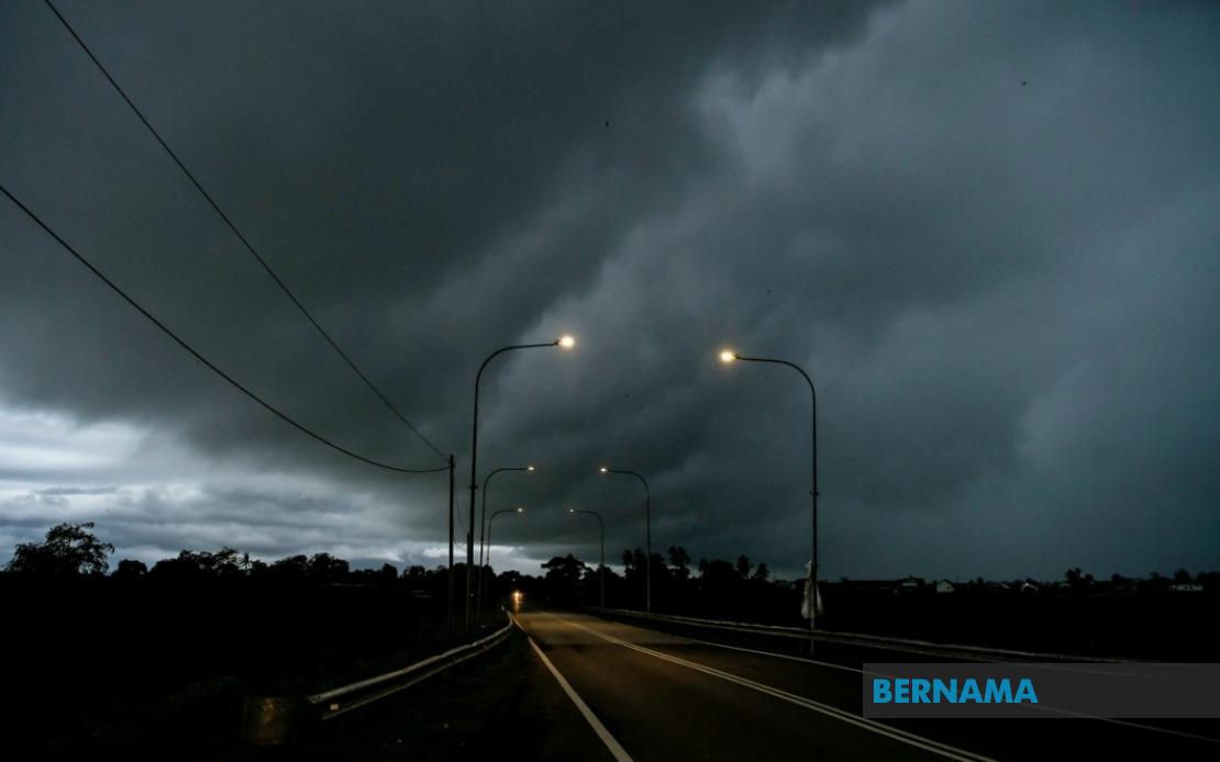
The Malaysian Meteorological Department has put much of the country on alert following the issuance of a thunderstorm and heavy rain warning that will remain in effect until 9 pm on June 18. The alert encompasses nine states along with Labuan, affecting a broad swathe of territory across the peninsula and East Malaysia as unstable atmospheric conditions develop across the region.
In the northern peninsula, the entire state of Perlis faces the threat of severe weather. Across the border in Kedah, residents in several districts including the popular tourist destination of Langkawi have been advised to prepare for the incoming conditions. The warning extends to other parts of the state including Kubang Pasu, Kota Setar, Pokok Sena, Padang Terap, Sik and Baling, suggesting that the system is moving across a significant geographical area.
Perak residents in multiple administrative zones are similarly affected. The districts of Kerian, Larut, Matang and Selama in the coastal regions face the warning, while inland areas including Kuala Kangsar, Kinta and Kampar are also in the danger zone. This distribution indicates that the weather system poses a risk across both lowland and elevated portions of the state.
Moving south along the peninsula, Pahang's vulnerable zones include the high-altitude Cameron Highlands resort area alongside lower-lying districts of Bentong, Bera and Rompin. The diversity of affected terrain suggests that flash flooding and landslide risks may vary considerably across these zones. In neighbouring Selangor, the Hulu Langat district inland from the capital region faces the brunt of the warning, while Negeri Sembilan's Jelebu and Jempol districts are on alert. Johor's southern districts of Segamat, Kluang and Mersing round out the peninsula's affected areas.
Sarawak's exposure to the weather system is extensive, with numerous divisions bracing for impact. Kuching division, encompassing both the state capital and outlying areas of Bau, faces the alert alongside Serian to the south. In the central regions, Samarahan division including the towns of Samarahan and Asajaya, as well as Sarikei division's Meradong area, are in the warning zone. The alert stretches to Sibu and Mukah divisions, with Kapit division in the interior including the towns of Song and Kapit also affected.
Further northeast in Sarawak, the divisions of Bintulu covering Tatau and Sebauh, and Miri covering Marudi, face the incoming system. Limbang in the state's far north completes the Sarawak picture, indicating that the meteorological event spans from the southwest to the northeast of the state. This expansive coverage suggests a broad weather pattern rather than isolated thunderstorm activity.
Sabah similarly faces multiple zones of concern. The interior regions including Sipitang, Kuala Penyu, Beaufort and Tambunan in the highlands are vulnerable, alongside the west coast areas. The east coast's Sandakan district, specifically the interior areas of Tongod and the lowland Kinabatangan region, round out Sabah's affected zones. The inclusion of both highland and coastal regions indicates that the system may produce localized but intense impacts depending on terrain and elevation.
Thunderstorms of this nature, particularly when affecting extended geographical areas over several hours, carry the potential for significant disruption. Beyond the obvious risks of lightning strikes and temporary visibility reduction, the heavy rain component of such systems frequently triggers flash floods in low-lying areas and drainage-challenged zones. In mountainous regions like Cameron Highlands and the interior of Sabah and Sarawak, the combination of steep terrain and heavy precipitation creates conditions conducive to landslides and debris flows. Communities near rivers and in flood-prone areas should remain vigilant and prepare for possible evacuation if conditions deteriorate.
The timing of the warning, extending until early evening, suggests that residents should expect the most severe conditions during the afternoon and early evening hours. This daytime to early-evening window is typical for convective systems in Malaysia's equatorial climate. Motorists are advised to exercise caution, particularly on highways crossing the affected zones, as visibility can deteriorate rapidly and road conditions may become hazardous. Those engaged in outdoor activities in the warning areas should seek shelter and delay non-essential travel plans.
For agriculture and commerce, the impact depends largely on the intensity and duration of rainfall in each district. While the region benefits from reliable rainfall during the monsoon periods, sudden downpours can damage crops ready for harvest and disrupt logistics operations. Fishermen along coastal areas should likewise exercise caution, as strong winds accompanying thunderstorms can create rough sea conditions even beyond the immediate warning zones due to wave propagation.
The Malaysian Meteorological Department's issuance of this warning underscores the importance of monitoring official weather alerts during the monsoon transitions and unstable weather periods. Residents in the affected areas are encouraged to remain updated through official channels and to take appropriate precautions. The agency's continued vigilance in issuing such alerts provides communities with critical lead time to prepare, reducing the potential for weather-related casualties and property damage across the nation.