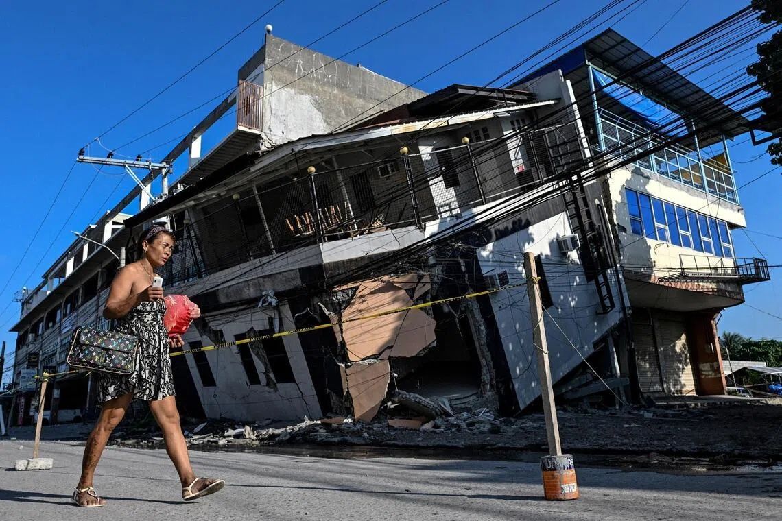
Arsenio Butil Jr. dropped to his knees as the 7.8-magnitude earthquake tore through southern Mindanao on June 8, his prayers interrupted by an extraordinary sight unfolding beyond his window. The coastline near his home in Glan, Sarangani province, was visibly transforming, with coral formations that had sat beneath the ocean for millennia suddenly breaking the surface. The temblor, one of the deadliest in recent Philippine history with at least 76 fatalities, had triggered far more than the typical destruction associated with seismic events. The geological forces unleashed by the shifting Cotabato Trench had fundamentally altered the physical geography of the region, a phenomenon that would challenge communities not just in the immediate aftermath but for years to come.
The mechanics behind this dramatic landscape transformation lie in the powerful tectonic movement of the Cotabato Trench, situated roughly 50 kilometres from Mindanao's coast. During the earthquake, the seafloor underwent what scientists term "coastal uplift", a process in which tectonic forces thrust sections of earth's crust upward, literally raising the seabed above water level. Initial assessments indicated that in certain areas, the seafloor had risen approximately two metres, extending the shore by as much as 200 metres in some localities. The affected zone stretched across nearly 100 kilometres, spanning between multiple towns and impacting an extensive population dependent on the ocean for their livelihoods.
For those living along the affected coast, the immediate aftermath presented both disorientation and danger. Butil Jr., a fisherman and pastor, described witnessing the ocean recede and advance repeatedly as waves and water movements adjusted to the new bathymetry. "The water receded. After a while, I saw it slowly returning. And then it receded again. Maybe three or four times," he recounted. Fish, unable to adapt to the rapid environmental changes, died en masse and floated on the surface, signalling to residents that something fundamentally abnormal had occurred. This phenomenon, while geologically routine over millennial timescales, arrived with shocking abruptness to populations accustomed to centuries of static coastlines.
Nane Danlag, a researcher at the Philippines Seismology and Volcanology Bureau in General Santos City, provided scientific perspective on the permanent nature of these changes. The emerging coastline represented a stable new equilibrium, not a temporary displacement that might reverse. She emphasised that such tectonic movements have shaped the Philippine archipelago continuously over millennia, part of the dynamic geological processes inherent to the region's position along the Pacific Ring of Fire. The Cotabato Trench itself reflects this broader tectonic reality—a zone of frequent seismic activity where the earth's crust undergoes constant adjustment. Notably, the area had experienced an unusual "swarm" of thousands of predominantly minor earthquakes in January, which a United Nations disaster risk reduction report released in May had flagged as a potential precursor to a larger seismic event.
Beyond the scientific curiosity of the geological transformation lay profound human consequences. In the hills above neighbouring settlements, approximately 100 residents, predominantly fishermen and their families, remained camped at higher elevations weeks after the earthquake. Datu Atom Malimpnig, a Maguindanaon tribal leader, explained that the community's reluctance to return to their destroyed homes stemmed not merely from the physical destruction but from existential fear. With the seabed having risen and the coastline dramatically altered, survivors harboured persistent anxieties that the ocean might surge forward with similar force, potentially triggering a devastating tsunami. The psychological toll of witnessing such radical environmental change, combined with the continuing tremors that rippled through the region, created a climate of profound uncertainty that rendered their former homes psychologically uninhabitable.
The economic ramifications extended beyond subsistence fishing communities to the tourism sector, which forms a crucial component of Mindanao's economy. The Isla Jardin del Mar resort, positioned along what was once a pristine white sand beach, faced an entirely transformed business environment. Where visitors had previously enjoyed direct water access, a wall of jagged, now-lifeless coral now separated the beach from navigable water, rendering the shoreline unsuitable for the swimming and water activities that justified premium resort rates. Staff members confronted the uncomfortable reality that the primary attraction marketing their destination had been fundamentally compromised by geological forces beyond any commercial entity's control. The extensive coral exposure also raised questions about ecological damage to marine ecosystems that sustained both fish populations and coastal tourism.
The disaster underscored Southeast Asia's vulnerability to seismic hazards, a reality particularly acute for island nations positioned along major fault lines and oceanic trenches. The Philippines, situated along multiple zones of tectonic activity, faces regular exposure to earthquakes that can trigger cascading secondary disasters including landslides, tsunamis, and the dramatic coastal modifications witnessed on Mindanao. For Malaysian readers, the Philippine experience offers instructive perspective on preparedness challenges faced across the region. While Malaysia experiences fewer major earthquakes than the Philippines, the earthquake zones along Sabah and Sarawak, and the potential for tsunamis generated by distant Pacific events, demand sustained attention to early warning systems and community preparedness protocols.
The aftermath of the June 8 earthquake revealed the limitations of conventional disaster recovery frameworks when geological transformation literally erases residents' former landscape. Butil Jr. highlighted a critical safety concern: the extensive ground fracturing across the region created structural instability that made reconstruction deeply hazardous. Long, visible cracks spider-webbing across affected areas suggested that subsequent earthquakes of similar or greater magnitude could trigger catastrophic secondary failures. This geological reality meant that communities could not simply rebuild their destroyed homes in their previous locations—the land itself had become unreliable as a foundation for reconstruction.
The seismic activity showed no signs of abating, with the Philippine Seismology and Volcanology Bureau recording more than 8,500 aftershocks since the June 8 principal shock. This relentless continuation of tectonic adjustment perpetuated residents' anxiety and complicated planning efforts. Each tremor, from barely perceptible to distinctly alarming, reinforced the message that the region remained in active geological flux. Even a 5.4-magnitude aftershock that struck during interviews with survivors served as a sobering reminder that the crisis phase had not definitively concluded. Authorities and communities faced the challenging task of managing recovery while acknowledging that further significant seismic events remained entirely plausible.
Looking forward, the transformed Mindanao coastline raises complex questions about land use planning, property rights, and community relocation in seismically active regions. The newly emergent shoreline, while geologically fascinating, represents a permanent alteration that necessitates fundamentally reconceiving how communities utilise and settle coastal areas. For residents like Butil Jr. and displaced families residing in hillside encampments, the path forward involved grappling with whether to rebuild in familiar but now-dangerous locations or establish entirely new settlements in different areas. This decision-making process, repeated across dozens of communities, would shape the region's demographics and economic geography for decades to come.
The June 8 earthquake's geological aftermath—the risen seabed, the extended coastline, the walls of exposed coral—serves as a visible manifestation of the powerful forces continuously reshaping Earth's surface. For the Philippine communities directly affected, this dramatic transformation transcends academic interest in tectonic processes. It represents a permanently altered reality that forces profound choices about habitation, livelihood, and community identity. As aftershocks continue and reconstruction debates commence, the Mindanao coastline stands as a stark reminder of the tectonic dynamism that underlies all of Southeast Asia, shaping the region's geology and, inevitably, the lives of those inhabiting it.